Geographic Location
Bagac is situated in the Western part of Bataan province. A plateau bounded on the West by China Sea, on the North-West by the Municipality of Morong, on the North-East by the Municipality of Abucay and Balanga, on the East by Pilar, Orion and Limay, and in the South by Mariveles.
The town is approximately 151 kilometers away from Manila and is accessible by both land and water transportation. A car running leisurely can easily reach the place within three hours passing through the North Luzon Expressway. From the monument of the Flaming Sword opposite Pilar municipal building, a concrete highway extends up to the junction of Bagac-Morong road where the Filipino-Japanese Friendship Tower majestically stands. Along this highway abound rivers, springs, waterfalls and verdant hills. It is near the Subic Bay Metropolitan Authority (SBMA), some 30 kilometers more or less.
The Export Processing Zone in Mariveles is connected to Bagac via the Bagac-Mariveles Road which is undergoing construction. Taking a ferry ride to Orion, Bataan from Manila, Bagac is reachable within two hours through the Roman Superhighway. The town of Bagac is 7 kilometers away from the mothballed Philippine Nuclear Power Plant, and 27.82 kilometers away from the city of Balanga, the major commercial center of the Province.
| Municipality | Distance from Bagac |
|---|---|
| Abucay | 32.54 |
| Bagac | 0.00 |
| Balanga | 27.82 |
| Dinalupihan | 53.94 |
| Hermosa | 46.44 |
| Limay | 40.91 |
| Mariveles | 72.58 |
| Morong | 22.66 |
| Orani | 41.69 |
| Oron | 33.60 |
| Pilar | 25.60 |
| Samal | 37.82 |
Bagac has the largest land area in Bataan with a total of 23,120 hectares or 231.20 square kilometers and occupies 16.84% of the province’s total area. Its political subdivision is comprised of 14 barangays, five (5) barangays of which is within the poblacion area namely: A. Ricardo, Bagumbayan, Tabing-Ilog, Ibaba, and Pag-asa.
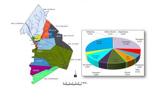
Bagac is composed of 14 barangays, 5 of which are urban while 9 are rural. Of the 14 barangays, Saysain has the largest land area of 67.81 square kilometers and comprises more than one-fourth (29.33%) of the total area of the Municipality. Bagumbayan, one of the urban barangays of Bagac is the smallest barangay in terms of land area. It has a total land area of 0.60 square kilometer or about 0.26 percent of the entire Municipality.
Bagac has the largest land area in Bataan with a total of 23,120 hectares or 231.20 square kilometers and occupies 16.84% of the province’s total area. Its political subdivision is comprised of 14 barangays, five (5) barangays of which is within the poblacion area namely: A. Ricardo, Bagumbayan, Tabing-Ilog, Ibaba, and Pag-asa.
Bagac is composed of 14 barangays, 5 of which are urban while 9 are rural. Of the 14 barangays, Saysain has the largest land area of 67.81 square kilometers and comprises more than one-fourth (29.33%) of the total area of the Municipality. Bagumbayan, one of the urban barangays of Bagac is the smallest barangay in terms of land area. It has a total land area of 0.60 square kilometer or about 0.26 percent of the entire Municipality.
| Barangay | Land Area (in sq. km.) | % Share |
|---|---|---|
| Municipality of Bagac | 231.20 | 100 |
| Atilano Ricardo | 2.79 | 1.21 |
| Bagumbayan | 0.60 | 0.26 |
| Banawang | 56.41 | 24.40 |
| Binuangan | 14.39 | 6.22 |
| Binukawan | 10.63 | 4.60 |
| Ibaba | 1.19 | 0.51 |
| Ibis | 12.86 | 5.56 |
| Pag-asa | 1.25 | 0.54 |
| Parang | 22.25 | 9.62 |
| Paysawan | 11.09 | 4.80 |
| Quinawan | 22.60 | 9.78 |
| San Antonio | 6.70 | 2.90 |
| Saysain | 67.81 | 29.33 |
| Tabing-ilog | 0.63 | 0.27 |